I’ve been searching for the perfect GPS for landscape photographers. I could use it for geo-tagging, sure enough and that may be a good side benefit. But what i really wanted was a GPS that would tell me two things – what time the sun was coming up and, here’s the kicker, where.
A lot of GPS’s boast that they have the sun and moon tables that provide sunrise and sunset, moonrise and moonset (is that a word?) times. And if you think about it, with a device that knows your location on the face of Mother Earth and it knows the date, it should be no big deal to determine when the sun rises and sets and the same goes for the moon. And like I said, a lot of GPS’s do just that. What they don’t do is tell you where which shouldn’t be any more difficult than telling you when.
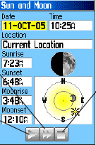
Well I found the GPS that does both. I found it at the toy store (read REI). The supervisor there helped me and together we figured out the best choice from a large variety of possibilities. It turns out to be the Garmin 60CSx. Now it doesn’t give you the azimuth in degrees but it does give a graphic that should be good enough.

Here’s the best picture I could find. The sun moves across the circle as the day progresses. When it gets to the the edge of the circle it is on the horizon. You can estimate the azimuth from its position relative to W (or E for sunrise).
Additionally, you can set different locations and dates. So if you’re planning a trip you can set the location and date and get the vital facts. This is especially good for sunrises where you may be scouting a location the day before or, worse yet, find yourself out in the dark hours before sunrise wondering where the sun will come up.
And as for the moon, it not only tells you when and where the moon will be rising and setting but also the phase of the moon.
Also built into the unit is an electronic compass that has a goof-proof calibration procedure. It tells you in plain English if you’re calibrating it correctly and whether you were successful or not.
So, with this new toy I can not only mark the coordinates of places that I want to shoot but also plan the best time and location for sunrise, sunset, moonrise and moon set.
So I’m a happy guy. And REI comes through one more time with the right product and great customer service. Thanks Leianna.
(376)

Check out the CompassBuddy. http://www.compassbuddy.com
I use it for location scouting in commercial photography.
Using sunrise and sunset azimuths that are easily available, you can determine how a location will light anytime of the year and plan your photo trips accordingly.
I use a Garmin Colorado 400T with the same features as the 60CSx, and they are terrific GPSs. On days where the moon will be a focus of my photography, I supplement it with a PC-based Heavenly-Opportunity shareware program (http://ho.fossilcreeksoft.com/) which provides azimuth and altitude information in degrees for the entire day (print it out).
If I am trying to get a shot of the moon rising over a hill or ridge, for example, I can determine the time and azimuth it will rise at that particular altitude (you need to use a compass with a clinometer).