I’m continuing a three-day photography scouting trip along California’s Central Coast. I’m preparing to lead a group here in November for the 2018 Central Coast and Napa Valley workshop. In the previous post (Photographing the California Central Coast – Day 1), I was joined by a friend and we covered the north end of the Sonoma Coast.
Today is the second day and I’m on my own. I enjoyed the company yesterday but today will be a more typical experience.
I started out by sleeping in. It was almost 8:00 when I finally rolled out of my sleeping bag and emerged from my tent to a blue sky. After yesterday’s overcast and foggy start, this was good news. A quick breakfast and a hot shower and I was ready to go. This day was going to cover more mileage than the day before but with fewer stops.
Gleason Beach was the first.
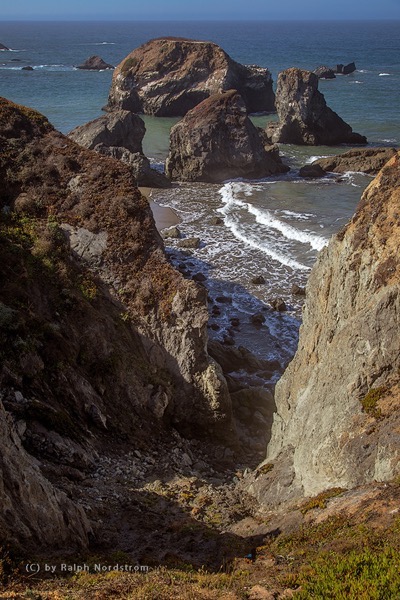
There were some sea stacks at this stop but they didn’t stand out. The severe gash in the cliff that led down to the cluster of sea stacks just off shore, however, was far more interesting. I timed the shot to get two concentric rings of surf which added the grace of curved lines to an overall rugged composition.
By the way, it’s also worth mentioning that in all of these seascapes where the ocean is visible, the horizon is flat. If I didn’t get it in the camera, I made sure that I straightened it in Lightroom.
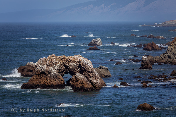
Continuing down the road I came to another arched rock, this one much more impressive than the one we found yesterday. And the composition was made more interesting with two smaller sea stacks framing the arch. I chose a composition that included the rocky coast and a hint of the coastal mountains in the distance – context. I think a tight shot of the arch itself with a good splash would also make a great shot.
Down the coast from here is Bodega Bay and the impressive Bodega Head, a huge peninsula that creates the bay. It’s large, not only in size but in elevation. From the main parking area are two beautiful vistas – up and down the coast.
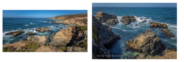
I cropped the first image, the one looking up the coast. There was a field of boulders in the foreground that I didn’t think added anything. The photograph is more focused without them. It’s really about the large foreground rocks, the cove and the surf.
The second photograph looks down the coast. It’s a wonderful view of the sea stacks from the headland high above. Instead of trying to capture a good splash from such a distance I opted for the patterns created by the white surf aftermath that encircled the rocks.
There’s a wonderful trail on Bodega Head what I indulged in. At the far south end is an incredible view of Bodega Bay in the foreground and mouth of Tomales Bay and the northern tip of Point Reyes in the far distance. And I was delighted with the curved lines of foam that stretched across the water.
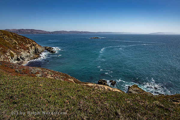
The next stop was quite a ways down the road. Where I was headed was beyond the mouth of Tomales Bay. I knew about this place but wasn’t planning on stop[Ing. But when I drove by, I just had to check it out. What place? Hog Island Oyster Company. Oh boy! Fresh oysters still in the shell, served on ice to keep them fresh. I found a picnic table and set about shucking my own oysters. Before I knew it, I had inhaled a dozen. Delicious.
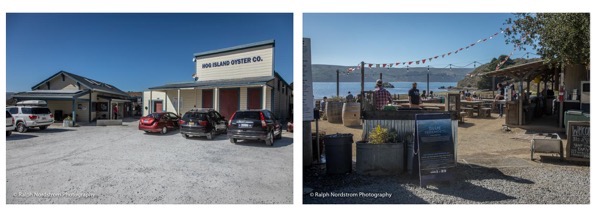
Next to the oyster factory was a row of buildings, perched over the bay on stilts. This was one of those moments one could not ignore.
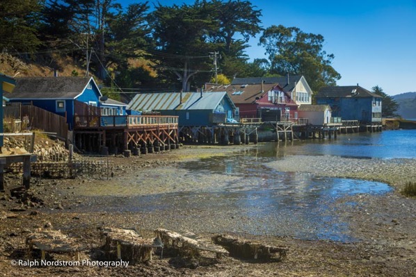
I found so much to like about this photograph and still do – the structures on stilts, the colorful paint jobs, the graceful curve in the water with the reflections, the line of trees coming down to the water and the border of rocks on the bottom., Everything was just right, With a happy stomach and a beautiful photograph in my camera, this unplanned stop turned out be doubly rewarding.
From here, I was headed to Point Reyes. The road took me all the way to the southern tip of Tomales Bay and then doubled back along the opposite side before heading the 15 miles out to the tip of Point Reyes. I was planning on making three stops. The first was the lifeboat cemetery. The lifeboat crews were housed in the shelter of Drakes Bay and braved stormy seas to rescue sailors who’s ship was wrecked on the treacherous rocks of Point Reyes. It’s inconceivable for us to imagine what deadly perils they faced. When other sailors were in distress, out they rowed in their small boats.
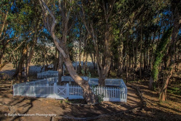
It was inevitable that some would give up their lives in their heroic attempt to save others. And to honor them they were laid to rest in this beautiful grove of eucalyptus trees at the top knoll overlooking Drake’s Bay. There isn’t anything that calls attention to the cemetery other than a small sign on the main road, You pretty much have to figure out where it is from that. But you can see that it is a peaceful, fitting place where these brave souls are at rest.
The next planned stop was a lane lined by giant cypress trees, leading back to an imposing white structure.
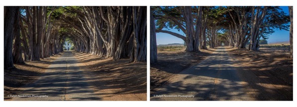
You may think these photographs are of two different tunnels but they are the same. In fact, they both have exactly the same number of trees. So what’s the difference? Well, I couldn’t resist playing with focal length and the effect it has on perspective. The photograph on the left is with a moderately long telephoto lens (105 mm focal length). This type of lens compresses distance and draws more attention to distant objects, in this case, the white structure at the end of the lane. The photograph on the right was taken with a wide-angle lens (24 mm focal length), This emphasizes the foreground and renders the distant background virtually insignificant. So the telephoto lens compresses the lane while the wide-angle lens stretches it. It’s fun to play around like this.
The building at the end of the road was a very important communications center known as the ‘Wireless Giant of the Pacific.” It was developed and run by RCA (Radio Corp[oration of America) and provided wireless ship-to-shore Morris Code communication all across the Pacific Ocean from 1946 to 1999. While much of the infrastructure has been dismantled, some remains. Other wireless stations that were created have long since been demolished, but this last remaining station is still manned by a group of volunteers and in operations every Saturday. What a fascinating history.
The next stop was not planned. The drive out the Point Reyes peninsula is a long one and passes by a number of historic ranches that are still in operation. This next photograph was one of those where you are driving by, see something, slam on the brakes, jump out and grab the shot.
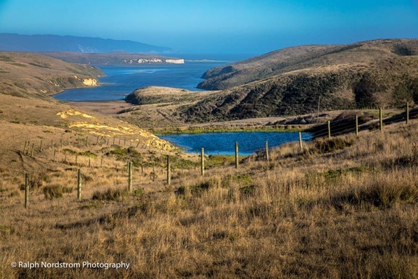
This is one of those moments when everything fell into exactly the right place. The rolling hills, fences, pond and bay are set off by the late afternoon sun. The scene is in perfect harmony and balance. It was a wonderful moment for me and I’m happy I was passing by at just the right time.
The third and final planned stop was at the southernmost tip of Point Reyes on a peninsula that defines the western edge of Drake’s Bay. There is a spot where you can see both sides, the seaward side with it’s tall cliffs carved by the relentless action of the sea and the more gentle side above the bay.
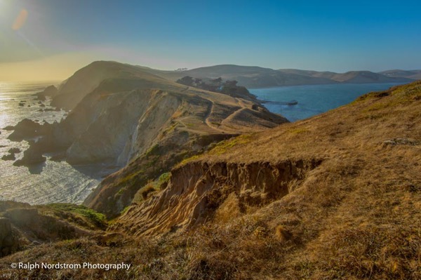
The contrast between the two sides is truly remarkable. On the bay side, you can see the pier from which the lifeboat crews launched their boats. On the sea side you can see the treacherous coast they had to navigate in the teeth of violent storms and raging seas. This tells the story of their heroism with unflinching intensity, It was a powerful way to end the day.
With these thoughts, I walked back to my car and headed back to my campsite, tent and sleeping bag. There would be one more exciting day tomorrow.
I’ll be back with a group in November, 2018. Come join us. Click here to check it out.
(55)
